Chapter One · Before the Boom
Citrus Land Northwest of Town
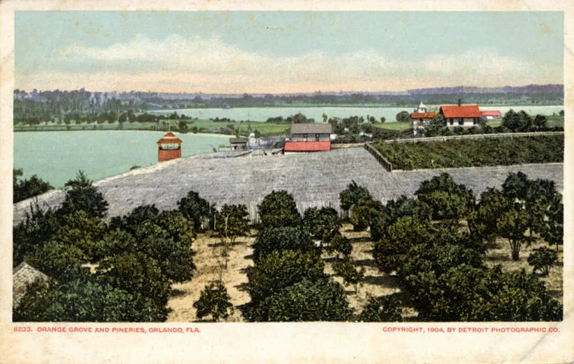
Before College Park was a name, it was citrus land northwest of downtown Orlando. The Florida historical marker for the Lake Ivanhoe Residential Historic District records one survivor from that first settlement: the 1882 Erricsson House at 19 West Princeton Street, a house that stands from the pre boom settlement, on a street that would later take a college's name.
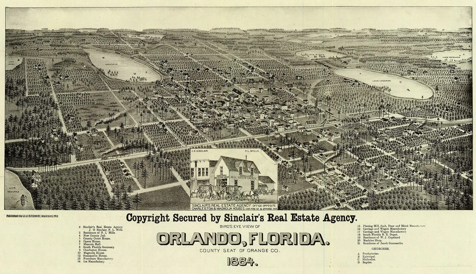
The grove era ended the way it ended across Central Florida. The Great Freeze of 1894 to 1895 stopped the earlier citrus grove settlement, and the College Park that eventually rose on the land was a new creation. Most of the neighborhood's fabric dates from the 1920s to the 1940s, the decades after the freeze, not before it.
Then and Now
The grove economy left one address you can still eat in. The guide's Great Southern Box Co. Food Hall & Bar works out of a 1930s citrus crate warehouse, restored to celebrate the immigrant cuisine that makes Orlando delicious. The crates are gone; the building kept the job of feeding the neighborhood.
Chapter Two · 1921
Rosemere, Where the Colleges Arrive on Paper
The defining era is the 1920s Florida land boom, and it starts with one developer's subdivisions. Walter Rose began platting subdivisions in 1921, and his Rosemere subdivision carried the first college streets: Princeton, Harvard, Yale and Cornell. No college came with them. The names were the point.
The 407 FYI Flashbacks card calls it plainly: a 1920s sales gimmick. Developers named the streets for colleges specifically to sell building lots during the Florida land boom, an Ivy League address for your new bungalow. The published description of Tana Mosier Porter's Arcadia history of College Park states the mechanism directly: the name originated not with a college, but with a developer who gave the streets in his new subdivision college names in 1921. Every street sign here is a real estate ad about a century old, and it worked.
Then and Now
The pitch is still posted on the corners. Princeton, Harvard, Yale and Cornell still run through the residential blocks behind Edgewater Drive, where the guide's Cups and Pups grew from a roadside cart into a bright Edgewater Drive coffee shop. The branding outlasted the boom that invented it.
Chapter Three · 1925 to 1954
Ground Broken for a Name
On February 26, 1925, ground was broken for the first subdivision to actually be called College Park, on the shores of Lake Ivanhoe near where Dartmouth Street meets the lake, bounded north to Princeton, west to Edgewater and east to University. The developer was the Cooper-Atha-Barr Company, CABCO, and its plat was the first of nine subdivisions to carry the name. The larger community took the name on.
The sequence is documented, and it runs backwards from what most people assume. Streets first in 1921, subdivision name in 1925, official name in 1954, when the naming of the College Park Post Office made it official. The collegiate branding worked so well that the post office ratified it three decades later. No college was ever the source.
Then and Now
The 1925 groundbreaking stood near where Dartmouth Street meets Lake Ivanhoe, and the lake end of the district still orients the walk. From the Ivanhoe shore it is a short climb to Edgewater Drive and Croissant Gourmet, the little piece of France the guide sends you to on the main street the plat helped create.
Chapter Four · 1923
Dann, Golfview and Dubsdread
College Park's western growth had its own developer. Hanford Carl Dann led the Dubsdread area from 1923, founding the White Stag Golf Course, later Dubsdread, with the Golfview subdivision plat filed the same year. Where Rose sold college names, Dann built a golf course and sold the neighborhood around it.
The pattern was the boom's pattern: an amenity first, then the plat, then the houses. Rose had used street signs as the amenity. Dann used fairways. Between Rosemere in 1921, Dubsdread and Golfview in 1923, and the first College Park subdivision in 1925, the citrus land northwest of downtown was fully spoken for in four years.
Then and Now
The Golfview blocks are still the quiet residential side of the district, while its social life runs along Edgewater Drive. That is where the guide points you to Ollie's Public House, the pub it describes as the place to ask College Park where it goes for everything at once.
Chapter Five · 2010 to 2011
The Boom, Written Into the Register
The historic district that resulted from the boom was listed on the National Register of Historic Places in 2010, 262 acres of boom era development built for a growing middle class, with a similar growth pattern after World War II. On the neighborhood's western lake edge, the Lake Adair and Lake Concord Historic District followed in 2011, 148 acres reflecting developers platting communities for wealthier residents among the lakes near the city limits from about 1920.
Through both districts runs the same corridor. Edgewater Drive, the commercial corridor through it all, was called Apopka Road in the 1920s. In 2002 it was restriped from four lanes to a more pedestrian friendly three, with bicycle lanes added, a main street deliberately slowed down to walking pace.
Then and Now
Edgewater Drive is the guide's main street today, at the walking pace the 2002 restriping intended. Turci Pasta rolls its pasta where you can watch through the window, dinner turns into dessert two doors down, and the corridor the boom built now belongs to the people strolling it.
The Index in the Street Signs
How the Streets Got Their Names
A neighborhood with no college confesses its branding in its street signs. The college street list below was checked against the City of Orlando GIS neighborhood map, which is why it can be printed with confidence, and why its absences can be stated just as plainly.
- Princeton Street: for Princeton University. One of Walter Rose's original 1921 Rosemere college streets.
- Harvard Street: for Harvard University. A Rosemere original from 1921.
- Yale Street: for Yale University. A Rosemere original from 1921.
- Cornell Avenue: for Cornell University. A Rosemere original from 1921.
- Dartmouth Street: for Dartmouth College. The 1925 groundbreaking for the first College Park subdivision stood near where Dartmouth meets Lake Ivanhoe.
- Stetson Street: for Stetson University, the Florida entry in the pattern, up the road in DeLand.
- Vassar Street: for Vassar College.
- Bryn Mawr Street: for Bryn Mawr College.
- Amherst Avenue: for Amherst College.
- Vanderbilt Street: for Vanderbilt University.
- Oberlin Avenue: for Oberlin College.
- DePauw Avenue: for DePauw University.
- Tulane Street: for Tulane University.
Three names on the usual lore list are not here. Columbia, Rutgers and Mount Holyoke were checked against the City of Orlando GIS College Park map consulted for this page and do not appear on it; the Wellesley in College Park is a 2005 mixed use development on Edgewater Drive, not a street. Smith Street exists, but a Smith College namesake is unverified, since Smith is also a common surname and no source ties this street to the college. Edgewater Drive's descriptive reading, along the lake edge, is likewise unverified as a naming act, though its 1920s name, Apopka Road, is documented. Ardsley Drive, in the 1950s Ardsley Manor development on Lake Silver, has no documented naming reason either.
The Story, On Foot
Walk It Today
Start where the name started, at the Lake Ivanhoe shore near Dartmouth Street, and read the signs as you climb into the neighborhood: Princeton, Harvard, Yale, Cornell, the 1921 pitch still posted on the corners. Then give the district its main street. Run Edgewater Drive the way the guide runs it: Shakers American Cafe for cinnamon roll pancakes, Cups and Pups to make the coffee official, and the Great Southern Box Co. Food Hall & Bar in its old citrus crate warehouse.
End the way College Park ends its own days. Turci Pasta for hand rolled pasta, QuesaLoco if birria is calling, and a nightcap on the covered patio at Ollie's Public House, where the neighborhood lands. Nothing on the route needs a campus. It never had one, and it never needed one.
From the Flashbacks
More history
Images and sources
Every photograph on this page is in the public domain. Follow any credit to its archive record.
- Orange grove and pineries beside Lakes Concord and Ivanhoe, Detroit Photographic Co. postcard, 1904: Wikimedia Commons. Public domain.
- Bird's eye view of Orlando, 1884, published by J. J. Stoner and printed by Beck and Pauli: Wikimedia Commons. Public domain.
Story sources: the Florida historical marker for the Lake Ivanhoe Residential Historic District, Orlando Memory and the College Park Neighborhood Association Historical Committee, Tana Mosier Porter's College Park history, the City of Orlando GIS College Park neighborhood map, and the 407 FYI Flashbacks. The sourced district history, street by street, lives on the District Histories page.